
High availability, mission-critical GIS
Geospatial platforms that keep working when a server, a disk or a whole site fails.
Most GIS was never designed to be always on
Many GIS installations began as a desktop project and grew into something people depend on every day: dispatching crews, approving permits, planning networks. One database server, one map server and a nightly backup nobody has restored is not an architecture for that.
We make GIS behave like the critical infrastructure it has become.
No single point of failure
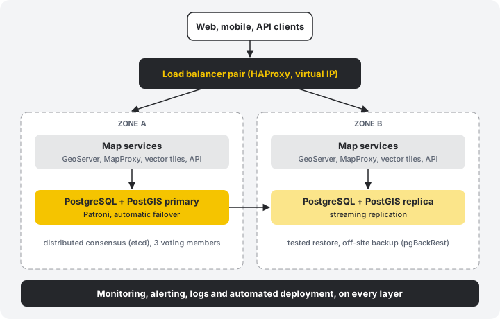
The details depend on your requirements and budget, but a typical design has these parts:
- Redundant entry: a load balancer pair with a virtual IP and health checks
- Stateless map services: several GeoServer, MapProxy or API instances that can be added or lost freely
- Replicated database: PostgreSQL/PostGIS with Patroni, streaming replication and automatic failover
- Separate failure zones: nodes spread over racks, data centres or sites
- Backups that work: point-in-time recovery with pgBackRest, off-site copies and regular restore drills
Availability is engineered, then proven
- 1
Define the target
We agree on availability, recovery time (RTO) and acceptable data loss (RPO) with you, because they decide the cost.
- 2
Design and automate
The whole platform is described as code, so it can be rebuilt identically in minutes.
- 3
Break it on purpose
Failover, restore and load tests before go-live. We kill nodes while you watch.
The unglamorous parts that decide uptime
Zero-downtime upgrades
Rolling updates of PostgreSQL, PostGIS and map services, rehearsed on a copy first.
Security and access
Single sign-on with Keycloak, role-based access, encryption, audit logging and a patch routine.
Performance at scale
Tile caching, vector tiles, query tuning and spatial indexing keep maps fast under load.
Runs where you need it
On-premise, private cloud, public cloud or air-gapped. Your data stays where your rules say.
Is your GIS ready for its worst day?
We can review your current setup and tell you where the risks are.